


Jackson, Wetzel, Roane, Braxton, Ritchie, Tyler, Gilmer & Calhoun Counties PUMA, West Virginia
About
Outline

Summary
| Unique Area Identifier | 194374 |
| Name | Jackson, Wetzel, Roane, Braxton, Ritchie, Tyler, Gilmer & Calhoun Counties PUMA |
| State | West Virginia |
| Area (square miles) | 3,168.10 |
| Land Area (square miles) | 3,142.82 |
| Water Area (square miles) | 25.28 |
| % of Land Area | 99.20 |
| % of Water Area | 0.80 |
| Latitude of the Internal Point | 38.99559870 |
| Longtitude of the Internal Point | -81.04937280 |
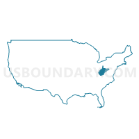
Maps

Jackson, Wetzel, Roane, Braxton, Ritchie, Tyler, Gilmer & Calhoun Counties PUMA in West Virginia
Download
Graphs
Select a template below for downloading or customizing gragh for Jackson, Wetzel, Roane, Braxton, Ritchie, Tyler, Gilmer & Calhoun Counties PUMA, West Virginia


Neighbors
Neighoring Public Use Microdata Area (by Name) Neighboring Public Use Microdata Area on the Map
- Athens, Gallia & Meigs Counties PUMA, OH
- Cabell, Wayne & Mason Counties--Huntington City PUMA, WV
- Greenbrier, Nicholas, Summers, Monroe & Pocahontas Counties PUMA, WV
- Harrison, Marion, Taylor & Doddridge Counties PUMA, WV
- Kanawha & Clay Counties--Charleston City PUMA, WV
- Monongalia & Preston Counties--Morgantown City PUMA, WV
- Ohio, Marshall, Hancock & Brooke Counties PUMA, WV
- Putnam, Boone & Lincoln Counties PUMA, WV
- Randolph, Upshur, Barbour, Lewis, Hardy, Grant, Pendleton & Tucker Counties PUMA, WV
- Washington (South) & Greene Counties PUMA, PA
- Washington, Morgan, Noble & Monroe Counties PUMA, OH
- Wood, Pleasants & Wirt Counties PUMA, WV
Top 10 Neighboring County (by Population) Neighboring County on the Map
- Kanawha County, WV (193,063)
- Monongalia County, WV (96,189)
- Wood County, WV (86,956)
- Harrison County, WV (69,099)
- Washington County, OH (61,778)
- Marion County, WV (56,418)
- Putnam County, WV (55,486)
- Greene County, PA (38,686)
- Marshall County, WV (33,107)
- Jackson County, WV (29,211)
Top 10 Neighboring County Subdivision (by Population) Neighboring County Subdivision on the Map
- District 3, Kanawha County, WV (50,055)
- District 4, Kanawha County, WV (47,899)
- Western district, Monongalia County, WV (27,045)
- West Augusta district, Marion County, WV (17,224)
- District 3, Marshall County, WV (12,042)
- Buffalo-Union district, Putnam County, WV (10,967)
- Northern district, Harrison County, WV (10,741)
- Western district, Jackson County, WV (10,576)
- Eastern district, Jackson County, WV (9,882)
- Northern district, Jackson County, WV (8,753)
Top 10 Neighboring Place (by Population) Neighboring Place on the Map
- New Martinsville city, WV (5,366)
- Ravenswood city, WV (3,876)
- Ripley city, WV (3,252)
- Paden City city, WV (2,633)
- Spencer city, WV (2,322)
- Harrisville town, WV (1,876)
- Glenville town, WV (1,537)
- Sistersville city, WV (1,396)
- Pennsboro city, WV (1,171)
- Sutton town, WV (994)
Top 10 Neighboring Unified School District (by Population) Neighboring Unified School District on the Map
- Kanawha County School District, WV (193,063)
- Monongalia School District, WV (96,189)
- Wood County School District, WV (86,956)
- Harrison County School District, WV (69,099)
- Marion County School District, WV (56,418)
- Putnam County School District, WV (55,486)
- Marshall County School District, WV (33,107)
- Jackson County School District, WV (29,211)
- Mason County School District, WV (27,324)
- Nicholas County School District, WV (26,233)
Top 10 Neighboring State Legislative District Lower Chamber (by Population) Neighboring State Legislative District Lower Chamber on the Map
- State House District 92, OH (123,037)
- State House District 93, OH (116,725)
- State House District 41, WV (71,101)
- State House District 50, PA (59,028)
- State House District 43, WV (56,711)
- State House District 32, WV (51,970)
- State House District 13, WV (39,847)
- State House District 4, WV (33,317)
- State House District 12, WV (20,112)
- State House District 34, WV (19,536)
Top 10 Neighboring State Legislative District Upper Chamber (by Population) Neighboring State Legislative District Upper Chamber on the Map
- State Senate District 20, OH (357,708)
- State Senate District 46, PA (235,908)
- State Senate District 817, WV (193,063)
- State Senate District 4, WV (117,998)
- State Senate District 3, WV (109,227)
- State Senate District 11, WV (108,768)
- State Senate District 12, WV (108,687)
- State Senate District 2, WV (101,327)
Top 10 Neighboring 111th Congressional District (by Population) Neighboring 111th Congressional District on the Map
- Congressional District 2, WV (648,186)
- Congressional District 6, OH (623,742)
- Congressional District 1, WV (615,991)
- Congressional District 12, PA (612,384)
- Congressional District 3, WV (588,817)
Top 10 Neighboring Census Tract (by Population) Neighboring Census Tract on the Map
- Census Tract 9637, Jackson County, WV (8,193)
- Census Tract 9549, Mason County, WV (7,391)
- Census Tract 108.01, Kanawha County, WV (6,659)
- Census Tract 9677, Gilmer County, WV (6,390)
- Census Tract 107.01, Wood County, WV (6,082)
- Census Tract 212, Washington County, OH (5,777)
- Census Tract 201, Putnam County, WV (5,670)
- Census Tract 9679, Braxton County, WV (5,303)
- Census Tract 209, Marshall County, WV (5,299)
- Census Tract 111, Kanawha County, WV (4,744)
Top 10 Neighboring 5-Digit ZIP Code Tabulation Area (by Population) Neighboring 5-Digit ZIP Code Tabulation Area on the Map
- 25071, WV (11,697)
- 26452, WV (9,676)
- 25271, WV (9,304)
- 26155, WV (8,823)
- 26164, WV (8,262)
- 25276, WV (7,752)
- 26170, WV (6,137)
- 25320, WV (6,084)
- 25045, WV (5,801)
- 26582, WV (5,335)